Friday, 12 August 2011

Scenic flight & El Questro Thursday 28/7/11

Up early for a flight, as we depart Kununurra , we fly over the Ord River Irrigation Area, Argyle Spillway & Top Dam as well as the Main Dam Wall and the Ord Hydropower station which provides power to Kununurra & Wyndham region. The flight continues over Lake Argyle and over Zebra Rock Peninsula which holds the world's only known deposits of the unique rock. It is a fine grain sandstone with rhythmic pattern of reddish stripes or spots against a white background.


Our flight continued over Lissadelle andTexas Downs Cattle stations which are separated by the boundary of Bow River. The pastoral leases are huge in the Kimberley, averaging 250000 hectares but the stocking rate is low with 2-3 cattle/km2 or 8 beasts/km2 on river frontage.

We have 20 minutes over The Bungle Bungles where we see the beehive shaped domes. These sandstone towers were formed over millions of years from sandstone and conglomerate from weathering by wind, rain and flowing water. The domes have formed case hardened skins which have a striped appearance, with layers of orange and dark grey resembling tiger skin. The grey bands are formed by Cyanobacteria - a single celled organism.
The Cyanobacterial grow on layers of sandstone where moisture accumulates. The orange bands are oxidised iron compounds that have dried out too quickly for the Cyanobacteria to grow.
Our flight over the Bungles came to an end as we meandered along Piccaninny Gorge & Creek & we saw the site where QANTAS filmed "I still call Australia Home" ad.

We return back over Rio Tinto's Argyle Diamond Mine which is the world's largest diamond mine, producing between 1/4 and 1/5 of the world's diamonds, equating to an average of 20 million carats of diamonds per year This mine is known for it's coloured diamonds, especially the intense pink diamonds - it's signature stone.

We arrive back in Kununurra after 2 hours & following a hearty Aussie brekkie we head out to El Expenso (oops I mean El Questro). Our first stop is Zebedee Springs for a foot splash in warm water before the paying guests arrive and the rangers get their whips out.

A look around El Questro Wilderness park has us proceeding to Emma Gorge. This is one of the Kimberley region's most well known and spectacular gorges. We enjoyed the walk & also the invigorating thermal trickle of water into a small pool which then plunges into a huge waterhole with a droplet waterfall enclosed on 3 sides by 65m sheer cliffs. We all brave the water with the older and more sensible sticking to the warmer areas. Angus however makes the most of this beautiful body of water and proceeds to do his icecube impression followed reluctantly by his more sensible sister. We then head back to Kununurra weary but happy. 

Wednesday, 3 August 2011

Kununurra to Wyndham and back ( just ) 27/7/11.


After a quiet catch-up day on Tuesday, we were on the road for a day trip 100km up the road to Wyndham, the most northern town in WA. Our first stop in Wyndham is the big croc, a 20m long statue that greets visitors to the town. Here we saw a local Aboriginal man brilliantly carving Boab pods, he said that he had been doing it since 5 years of age and he looked about 65 yo. 

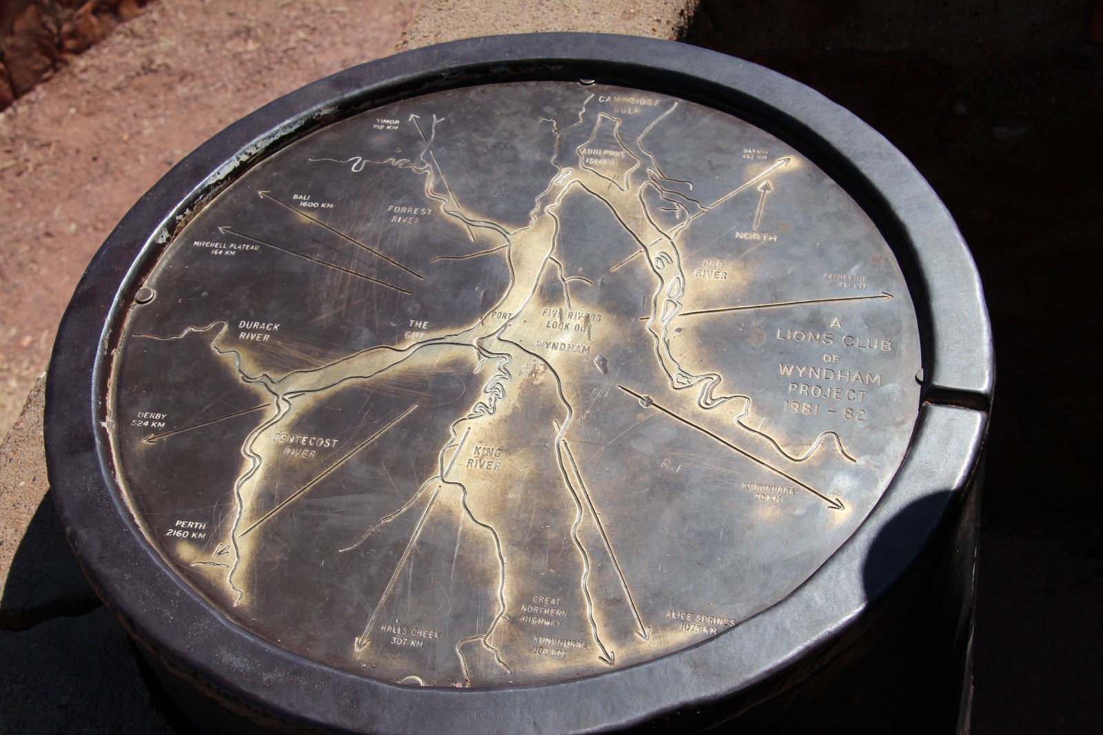
From there we travel up the Bastion Range to the Five Rivers Lookout. From there we are able to identify the King, Ord, Durack, Forrest, and the Pentacost rivers flowing into the Cambridge Gulf. We also spend time watching numerous industrial activities including a ship being loaded from a barge and roadtrains delivering ? iron ore or bauxite.
On the way out of town, we visited an Afghan Cemetery which contains the graves of the early Afghan settlers & cameleers (1890's) who provided an important means of transport between the cattle stations & the towns of the region. The graves are large due to the lead camel often being buried with it's master.
We turn onto King River Road and travel along salt pans and more corrugations to an Aboriginal Art site and a Prison Tree. It was here that prisoners were detained in the hollow Boab. Past Digger's Rest Station, we travel via the Karunjie Track.

This track is a 52km "short cut" from Wyndham to the Gibb River road however it takes about 3 1/2 hours over not only corrugations, river crossings, deep bull-dust and lots of wash-outs but also offered scenic views of the Cockburn Range.


 We added a half hour to the trip when Mum got bogged in a table drain full of black soil and required a tow by a stockman doing the boundary run with his parents (who incidentally are from Beaudesert).


We washed off the mud when we crossed the Pentacost River and headed back into Kunnunurra via the Gibb River Road.

Tuesday, 2 August 2011

Big Horse Creek to Kununurra Monday 25th July

Located in Gregory National Park is a large Boab tree that stands at the campsite of explorer Augustus Gregory as he started his Northern Austrian expedition undertaken October 1855 until July 1856.
We have to relinquish very little to the quarantine bin at the border as we learnt from others who had a less fortunate experience last year.

We visited Lake Argyle which is the largest man made lake in Australia. It was formed in 1972 after damming the Ord River and is designed to hold 10 763 000 megalitres and covers 1000 m2. For navigation purposes, it is classified as an inland sea.

We have a scenic croc spotting adventure on Spillway Creek before heading for the dam wall up the top. After our site-seeing we head into Kununurra where we set up camp at Kimberlyland Caravan Park with a view overlooking Lake Kununurra.

Western Australia bound. Sunday 24th July

After speaking with various 4WD owners and visitor centres, we decide that the road to Jim Jim Falls can wait for us to visit another day, next time with a snorkel. Twin Falls has been temporarily closed, all due to the late wet season.
Through Katherine and onto the Victoria Highway, through Gregory National Park and over the Victoria River Crossing. This NP is the Northern Territory's 2nd largest park and features spectacular landscapes of deep valleys and gorges, grassy plains, ancient boab trees and of course the Victoria River.

We make camp at Big Horse Creek, still in the NP.

Kakadu Saturday, 23rd July 2011


Up early and into the car for a quick drive to the Mardugal camp ground for a ranger led walk through the woodland of this region. The varied ecological areas in Kakadu are incredible ranging from tidal flats, stone country, monsoon forests, savanna woodlands, floodplains and billabongs. After our walk, we headed back to camp where we decided to drive down a nearby track to sandy billabong where we found an idyllic waterside area to have lunch. After absorbing the views and our lunch we set off for more exploring of the park. We headed to the Warradjan Aboriginal Cultural Centre. This building resembles the pig-nosed turtle from which it shares it's name, and houses a wide range of informative displays of traditional life and early colonial history.


From there we headed to the Yellow Water Wetlands and to Cooinda. From there the road took us to Maguk and a wander through monsoon forest and along a sandy and rocky creek to a small waterfall and plunge pool before heading back to camp for a well earned rest. 

Kakadu 22nd July 2011

After surviving the mossie bombardment and discovering a black snake that had been smothered by trying to sleep under the tent, we attended a traditional painting demonstration by two men from Arnhem land. We learnt how to make paint brushes from river reeds and were then given the chance to use them.  


We headed for Muriella Park were we set up camp again. After we had settled in we set off for  more rock art at Noulangie. Another informative ranger talk, this time about Namarrgon (Lightning Man) and more impressive scenery.


Back to camp where we were delighted to see the squadrons of flying taxmen from the previous night hadn't made the journey with us.

Thursday, 28 July 2011

Entering Kakadu 21st July

  
We pick up our park passes and enjoy the exhibits and presentations at Bowali Visitor Centre before setting up camp at Merl campground. We spend some of the arvo at Cahill's Crossing which is the main river crossing into northern Arhnem Land. We were fortunate to arrive there at the peak of high tide. We saw 4 large salties and numerous non reptiles fishing for barra at the crossing. We observed the rapid reseeding of the water level - about 700mm in just 20 minutes. In this time we saw some brave locals crossing in their vehicles with water washing over their bonnets. Some had snorkels, some didn't. All while a salty watched from about 15m from them, probably wondering where he left his tin snips.


We attend ranger guided walks at Ubirr past several rock art sites which are different from those at Uluru as these are xray and contact art. We learn about aboriginal law, moiety, creation & kinship as well as the Rainbow Serpent.


The day finished upon a rocky lookout with a sunset view of the Nadab floodplain at Ubirr.