Monday, 22 August 2011
Newman 7-8 August
After packing up camp we headed down to the port of Port Hedland. We watched some huge ore ships being loaded before taking our leave and moving onto Newman, 400km inland. We settled in for the night for we had to be up early to pack up in order to go on a tour of the Mt Whaleback Mine. Owned by BHP, it is the largest open cut iron ore mine in Australia. We were taken into the mine and up to the lookout which is the highest point in the mine. Although this lookout was perfect for gazing into the depths of the mine, it was actually 150mt lower than when the mine was started. It boggles the mind to imagine the volumes of iron ore and other material that had already been removed. The mine is surrounded by man made mountains that are the overburden that the company have to stockpile in order to rehabilitate the area when mining ceases. We were able to see the huge haulpacks ( dump trucks ) being loaded and the delivery their load to the crushers where the ore was processed prior to being loaded onto trains for the 8hr journey to Port Hedland. We were well informed by the time we returned to the information center where we were able to get up close to some of the huge machines that had been donated to the center. Angus was not happy to see the 'DO NOT CLIMB' signs. We then said farewell to Newman before heading onto Karijini National Park.
Broome to Port Hedland via Marble Bar 5-6 August
We leave Broome and continue our journey south. After a spot of free camping on the banks of the De Grey River ( located halfway between De White and De Black Rivers!!) we travel onto Marble Bar, the hottest town in Australia. Luckily it's winter and so we don't have to risk melting into the pavement. After discussing the road conditions south to Newman with some locals we decide to backtrack north to Port Hedland. But first we head out to the 'Marble Bar' from which the town gets it's name. We were a bit disappointed when we arrived but after a spell of exploring we were more than impressed with the striking rock formations and colours of the famous Marble Bar which is actually a jasper deposit and not marble. Leaving Marble Bar we head for Port Hedland where we are greeted with massive trains that stretch for kilometers and various ore handling machines that soar into the sky. Angus is almost beside himself at the sight of these enormous manmade structures called Stackers and Reclaimers. After finding a place to stay we settle in for the night.
Cape Leveque Beagle Bay 4th August
The Sacred Heart Church is our destination for today. We travelled along the Cape Leveque Road which was a bit of a challenge in places. No rocks for once but sections of corrugations and plenty of tree roots that you need to avoid or risk staking a tyre. The church is located at Beagle Bay and was built by the Trappist Monks with the help of the local community. Construction commenced in 1915 and took 2 years to complete. The interior of the church has been exquisitely decorated with mother of pearl, cowries, volutes, and olive shells. The result is a " fusion of traditional Nyul Nyul, Mimanborr and Bard symbols and materials with traditional Christian symbols and European mosaic techniques resulting in a unique expression of art and faith." After spending some time admiring the church we had lunch before heading back to Broome. The Japanese and Chinese cemeteries were our next stop. Due to to the dangerous conditions many of the divers lost their lives and were buried here. We then visited the port before heading back to camp where Claire and Angus spent the rest of the afternoon exploring the beach in front of the caravan park. There we found the Pioneer's Cemetery where a number of Broome's early pioneers have their final resting place overlooking the ocean. A meal of fish and chips finishes off a great day.
Broome 3rd August 2011
Aahh.... Pearl, pearls, pearls and more pearls. Big ones, small ones, freshwater ones, saltwater ones, roundand coloured ones, what is a girl to do.
Firstly visited a free Pearl information centre & exhibit and found out what is real or fake; farming practices and quality issues before wandering Chinatown and enjoying the contradiction of Broome, where historical buildings stand side by side with modern world architecture.
At "Pearl Luggers", we took an interactive journey through the colourful history of Broome including the multicultural population that were lured by the promise of finding their fortune. We heard enthralling tales of Pearl Master's extravagance and their extravagant lifestyle. We learned more about the life of the diver and how 1 in 3 lost their lives on the first dive and when you see the gear that they wore, you can understand why. We tasted pearl meat which usually retails at $120/kg in Australia and $400-600/kg on overseas markets. The highlight & finale was where Claire wore a strand of pearls worth $9000 and Angus got to hold one of the world's most perfect pearls worth $100 000. The kids were happy and the parents were very very nervous.
Windjana to Broome Tuesday 02/08/11
This was an amazing, easy walk where we were able to view life from the Devonian era with a mrine fossil - a nautiloid. Soon brought back to reality by a 3.5m Olive Python just lazing on the sand digesting it's breakfast.
Reflective gorge scenery, lush shady vegetation, noisy corellas and freshwater crocs sunning themselves on the river bank were also highlights of this walk.
We head along the last of the Gibb river Road to Derby where we lunch by the jetty. Derby is best known for it's 12m tidal variation, the largest in Australia and 2nd largest in the world. We visit another Prison tree which was once used as an overnight lockup but now housed a swarm of bees.
Tourists in Derby can also visit the Horizontal Waterfall which is an unusual phenomenon in a narrow gap at the mouth of a large inletin the Buccaneer Archipelago. At high tide the inlet fills, & as he tide turns, the water begins to drain out through the gap. During Spring tides, the rate at which the water is able to escape from the inlet cannot keep pace with the falling tide and thus a horizontal waterfall is produced. We will have to save this for next time as you can only get there by boat or float aircraft and Broome awaits us.
Geike Gorge to Windjana NP Monday 01/08/11
This Gorge was once part of the barrier reef that encircled the Kimberley during the Devonian geological period 350 million years ago. We were disappointed at the walk here as the limestone rocks were still covered in dense silt from the late wet season and were instead fascinated by the flood level markers of the last 12 years.
We travel along Leopold Downs Road to Tunnel Creek which is an underground passage beneath the limestone Napier range. It was here that aboriginal police tracker / freedom fighter hid out for 3 years after he killed a policeman. It was easy to see why & how he hid out in the maze of darkness.
Our camp tonight is at Windjana Gorge where we were pleasantly surprised to find not only hot showers but flushing toilets in the middle of nowhere.
Mini Palms to Fitzroy Crossing Sunday 31st July
Our final walk in Purnululu NP has us walking along a stony riverbed clambering over large conglomerate rocks, among tall Livingstonia palms and high cliffs. Termites and palms seem to balance precariously high above the ground. The path ends in a large cavern, an awesome sight.
We make our way through Hall's Creek and make camp at Fitzroy Crossing. We spot our first clouds for weeks just as the sun is setting.
Friday, 12 August 2011
Picaninny Gorge to Echidna Chasm Saturday 30th July 2011
Purnululu National park covers approx. 45000 hectares with an array of banded sandstone domes and conglomerate and we head along Picaninny Creek in order to see these domes towering majestically around us. We continue our walk onto Cathedral Gorge through striped domes, pebbles, potholes & honeycomb rocks that lead to an ampitheatre. Here an elderly gentleman entertains the crowd with his singing before we are all singing "Walzing Matilda".
We drive to the other end of the park for the walk to Echidna Chasm which was a spectacular walk which was completely different to the others. Instead of the honeycomb domes, we were greeted with a trudge along a stony creek bed before having steep conglomerate walls narrow to form a chasm just a metre wide. Our day was competed with a sunset view of the western face of the Bungles at Kungkalanyi Lookout.
Bungles Bound - Friday 29/7/11
Packed up camp and hit the road for Purnululu National Park. As we had heard that the road in was rough and hard going we allowed 3hrs to travel the 50km into the park. We stopped outside the park and had lunch. This gave the tyres a chance to cool before we dropped the pressure in them for the rough ride in. We had a fun drive with 109 watercourse crossings (78 dry and 31 wet) and arrived at the visitor's center 1.5 hrs later.

 We found the road wasn't as bad as we had been told (road conditions are dependent on recent weather and when the grader has been through). After paying the required fees we headed for our campsite where we setup the tent before heading for the nearby lookout for a beautiful view of the sun setting over the southern part of the Bungle Bungles.
We also had the unexpected visit of a paraglider we had seen on our flight yesterday who was using the lookout for his landing site. His name was Ben and he was taking photos of the Bungles. Whether he had permission or not was anybody's guess.


 We found the road wasn't as bad as we had been told (road conditions are dependent on recent weather and when the grader has been through). After paying the required fees we headed for our campsite where we setup the tent before heading for the nearby lookout for a beautiful view of the sun setting over the southern part of the Bungle Bungles.
 We also had the unexpected visit of a paraglider we had seen on our flight yesterday who was using the lookout for his landing site. His name was Ben and he was taking photos of the Bungles. Whether he had permission or not was anybody's guess.

Scenic flight & El Questro Thursday 28/7/11
Up early for a flight, as we depart Kununurra , we fly over the Ord River Irrigation Area, Argyle Spillway & Top Dam as well as the Main Dam Wall and the Ord Hydropower station which provides power to Kununurra & Wyndham region. The flight continues over Lake Argyle and over Zebra Rock Peninsula which holds the world's only known deposits of the unique rock. It is a fine grain sandstone with rhythmic pattern of reddish stripes or spots against a white background.

 Our flight continued over Lissadelle andTexas Downs Cattle stations which are separated by the boundary of Bow River. The pastoral leases are huge in the Kimberley, averaging 250000 hectares but the stocking rate is low with 2-3 cattle/km2 or 8 beasts/km2 on river frontage.

 We return back over Rio Tinto's Argyle Diamond Mine which is the world's largest diamond mine, producing between 1/4 and 1/5 of the world's diamonds, equating to an average of 20 million carats of diamonds per year This mine is known for it's coloured diamonds, especially the intense pink diamonds - it's signature stone.


 Our flight continued over Lissadelle andTexas Downs Cattle stations which are separated by the boundary of Bow River. The pastoral leases are huge in the Kimberley, averaging 250000 hectares but the stocking rate is low with 2-3 cattle/km2 or 8 beasts/km2 on river frontage.
We have 20 minutes over The Bungle Bungles where we see the beehive shaped domes. These sandstone towers were formed over millions of years from sandstone and conglomerate from weathering by wind, rain and flowing water. The domes have formed case hardened skins which have a striped appearance, with layers of orange and dark grey resembling tiger skin. The grey bands are formed by Cyanobacteria - a single celled organism.
The Cyanobacterial grow on layers of sandstone where moisture accumulates. The orange bands are oxidised iron compounds that have dried out too quickly for the Cyanobacteria to grow.

Our flight over the Bungles came to an end as we meandered along Piccaninny Gorge & Creek & we saw the site where QANTAS filmed "I still call Australia Home" ad.
 We return back over Rio Tinto's Argyle Diamond Mine which is the world's largest diamond mine, producing between 1/4 and 1/5 of the world's diamonds, equating to an average of 20 million carats of diamonds per year This mine is known for it's coloured diamonds, especially the intense pink diamonds - it's signature stone.
We arrive back in Kununurra after 2 hours & following a hearty Aussie brekkie we head out to El Expenso (oops I mean El Questro). Our first stop is Zebedee Springs for a foot splash in warm water before the paying guests arrive and the rangers get their whips out.
A look around El Questro Wilderness park has us proceeding to Emma Gorge. This is one of the Kimberley region's most well known and spectacular gorges. We enjoyed the walk & also the invigorating thermal trickle of water into a small pool which then plunges into a huge waterhole with a droplet waterfall enclosed on 3 sides by 65m sheer cliffs. We all brave the water with the older and more sensible sticking to the warmer areas. Angus however makes the most of this beautiful body of water and proceeds to do his icecube impression followed reluctantly by his more sensible sister. We then head back to Kununurra weary but happy.

Wednesday, 3 August 2011
Kununurra to Wyndham and back ( just ) 27/7/11.
After a quiet catch-up day on Tuesday, we were on the road for a day trip 100km up the road to Wyndham, the most northern town in WA. Our first stop in Wyndham is the big croc, a 20m long statue that greets visitors to the town. Here we saw a local Aboriginal man brilliantly carving Boab pods, he said that he had been doing it since 5 years of age and he looked about 65 yo.
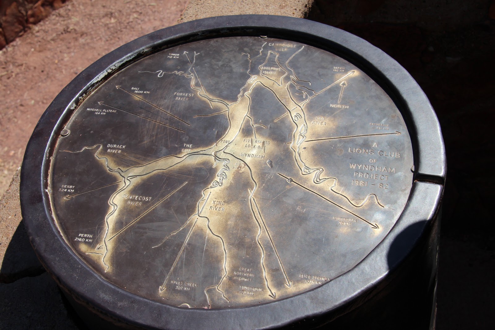
From there we travel up the Bastion Range to the Five Rivers Lookout. From there we are able to identify the King, Ord, Durack, Forrest, and the Pentacost rivers flowing into the Cambridge Gulf. We also spend time watching numerous industrial activities including a ship being loaded from a barge and roadtrains delivering ? iron ore or bauxite.
On the way out of town, we visited an Afghan Cemetery which contains the graves of the early Afghan settlers & cameleers (1890's) who provided an important means of transport between the cattle stations & the towns of the region. The graves are large due to the lead camel often being buried with it's master.

We turn onto King River Road and travel along salt pans and more corrugations to an Aboriginal Art site and a Prison Tree. It was here that prisoners were detained in the hollow Boab. Past Digger's Rest Station, we travel via the Karunjie Track.
This track is a 52km "short cut" from Wyndham to the Gibb River road however it takes about 3 1/2 hours over not only corrugations, river crossings, deep bull-dust and lots of wash-outs but also offered scenic views of the Cockburn Range.

We added a half hour to the trip when Mum got bogged in a table drain full of black soil and required a tow by a stockman doing the boundary run with his parents (who incidentally are from Beaudesert).
 We washed off the mud when we crossed the Pentacost River and headed back into Kunnunurra via the Gibb River Road.
Tuesday, 2 August 2011
Big Horse Creek to Kununurra Monday 25th July
Located in Gregory National Park is a large Boab tree that stands at the campsite of explorer Augustus Gregory as he started his Northern Austrian expedition undertaken October 1855 until July 1856.
We have to relinquish very little to the quarantine bin at the border as we learnt from others who had a less fortunate experience last year.


Western Australia bound. Sunday 24th July
After speaking with various 4WD owners and visitor centres, we decide that the road to Jim Jim Falls can wait for us to visit another day, next time with a snorkel. Twin Falls has been temporarily closed, all due to the late wet season.
Through Katherine and onto the Victoria Highway, through Gregory National Park and over the Victoria River Crossing. This NP is the Northern Territory's 2nd largest park and features spectacular landscapes of deep valleys and gorges, grassy plains, ancient boab trees and of course the Victoria River.
 We make camp at Big Horse Creek, still in the NP.
Through Katherine and onto the Victoria Highway, through Gregory National Park and over the Victoria River Crossing. This NP is the Northern Territory's 2nd largest park and features spectacular landscapes of deep valleys and gorges, grassy plains, ancient boab trees and of course the Victoria River.

Kakadu Saturday, 23rd July 2011

Up early and into the car for a quick drive to the Mardugal camp ground for a ranger led walk through the woodland of this region. The varied ecological areas in Kakadu are incredible ranging from tidal flats, stone country, monsoon forests, savanna woodlands, floodplains and billabongs. After our walk, we headed back to camp where we decided to drive down a nearby track to sandy billabong where we found an idyllic waterside area to have lunch. After absorbing the views and our lunch we set off for more exploring of the park. We headed to the Warradjan Aboriginal Cultural Centre. This building resembles the pig-nosed turtle from which it shares it's name, and houses a wide range of informative displays of traditional life and early colonial history.

From there we headed to the Yellow Water Wetlands and to Cooinda. From there the road took us to Maguk and a wander through monsoon forest and along a sandy and rocky creek to a small waterfall and plunge pool before heading back to camp for a well earned rest.
Kakadu 22nd July 2011

After surviving the mossie bombardment and discovering a black snake that had been smothered by trying to sleep under the tent, we attended a traditional painting demonstration by two men from Arnhem land. We learnt how to make paint brushes from river reeds and were then given the chance to use them.
 We headed for Muriella Park were we set up camp again. After we had settled in we set off for more rock art at Noulangie. Another informative ranger talk, this time about Namarrgon (Lightning Man) and more impressive scenery.
Subscribe to:
Posts (Atom)